x

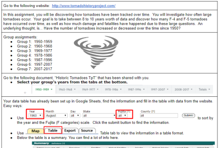
A digital study of Awesome Landforms

In this one-day activity students will read and learn about the different types of landforms that are out there. They will then, as groups, create a Google Doc and create a table within it. They will find examples, describe the origins, and find an image that represents, coastal plains, interior plains, folded mountains, upwarped mountains, fault-block mountains, volcanic mountains, and plateaus. After they are done students will share some unique discoveries that they have made with the class and compare them with their discoveries with those of others.

Earth Science Tornado Statistics Project

 In this assignment, students will access a database with documented tornadoes since 1950. Students will use a Google spreadsheet as a class to gather data from the website. Data they will look into for each year are: Total tornadoes, Longest path, widest path, total F4s, total F4 fatalities, total F5s, total F5 fatalities, the month with the most tornadoes, and deadliest tornado sizes. When all data is collected there is a totals tab that contains three graphs that students can analyze. Students will also investigate and view states that have the most tornado events.

Water Rocket Lab Instructions and Questions

If you are a science teacher and don't have a water rocket lab, you should begin.  This experiment is the highlight of our year.  This is a doc for a higher-end physics class and contains math calculations.  Students have restrictions as to rocket design.  We launch twice.  On the first day, we build, launch, and calculate distances.  The next day we do the say, but his time they should be making repairs to see if they can get it to fly further.

Famous Volcanoes

In this web research activity, students will research 14 volcanoes via the internet. All of these volcanoes are famous for either their size of eruption or the continuous eruptions that they have. They are famous for causing large tsunamis, huge pyroclastic flows, and lahars, as well as some that might not be so dangerous but have flowed continuously for many years. Students will enhance their geography knowledge by plotting the volcano's location on a plate tectonic map. They will find out when the last eruption occurred.

The Rock Cycle Activity

Looking for a new way to teach the rock cycle? Check out this exciting twist on a classic activity from EducationalResource.org! In this activity, students roll a die and follow instructions to create their own unique rock cycle. This hands-on approach helps students understand that there is no one set path for a rock to follow as it undergoes the process of becoming a new type of rock. As a class, students can share their individual rock cycle paths and compare them to see the infinite possibilities that exist within the rock cycle.

Subscribe to Lab